Where is the lowest and highest point standard of North Korea?
북한의 수준원점은 어디에 있나요? | 북한에서 가장 높은 곳은 어디인가요?

Errors in detail
Elevation – lowest point : Sea of Japan 0 m | highest point : Paektu-san 2,744 m
오류 내용(번역)
해발고도 최저점 : 일본해 0 m | 최고점 : 백두산 2,744 m
Original Image
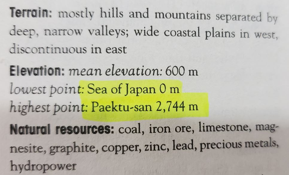
Lowest & Highest point of North Korea
page 523
What is wrong with the content?
무엇이 잘못되었나요?
The term ‘East Sea’ should be used rather than ‘Sea of Japan’. The term ‘Sea of Japan’, which the Japanese government claims, is a remainder from Japanese Imperialism. ‘East Sea’ has been a part of Koreans’ lives historically. In fact, the Origin Point Of (North) Korea Geodetic Vertical Datum(the standard datum of leveling) is just offshore of Wonsan city.
In between North Korea’s lowest point(offshore Wonsan) and South Korea’s lowest point(offshore Incheon), there is a difference of 6m. According to South Korea’s standard, Paektu(Baekdu)-san Mountain is 2,744m, but in North Korea’s standard, it is 2,750m.
‘일본해’ 대신에 ‘동해’라는 표현이 사용되어야 합니다. 일본 정부가 주장하는 ‘일본해’ 표기는 일본 제국주의의 잔재입니다. ‘동해’는 역사적으로 줄곧 한국인들의 삶의 일부분이었습니다. 북한의 해발 고도 기준점 (수준원점)은 원산 앞바다에 있습니다.
북한의 수준원점(원산 앞바다)과 남한의 수준원점(인천 앞바다)은 6m 차이가 있습니다. 따라서 남한의 기준에 따르면 백두산의 높이는 2,744m 이지만 북한의 기준에 따르면 백두산의 높이는 2,750m 입니다.
If so, how should it be properly explained?
어떻게 수정해야 할까요?
Sea of Japan 0m → offshore of Incheon metropolitan city 0m
2,744m → 2,750m
일본해 → 인천광역시 앞바다
The captured image is originally from https://www.cia.gov/the-world-factbook/countries/korea-south
The erred contents of this page was confirmed to be stated on the above website as of February 25, 2021, and may have been corrected or updated since.
The information on this page may not be identical as the publication information below.
- Full title : The CIA World Factbook 2021-2022
- Publisher : Skyhorse (2021)
- ISBN : 9781510763814
- page number : 523