Did Goryeo belong to one of Mongol Khanates?
고려는 몽골 칸국 중 하나에 속했었나요?
Errors in detail
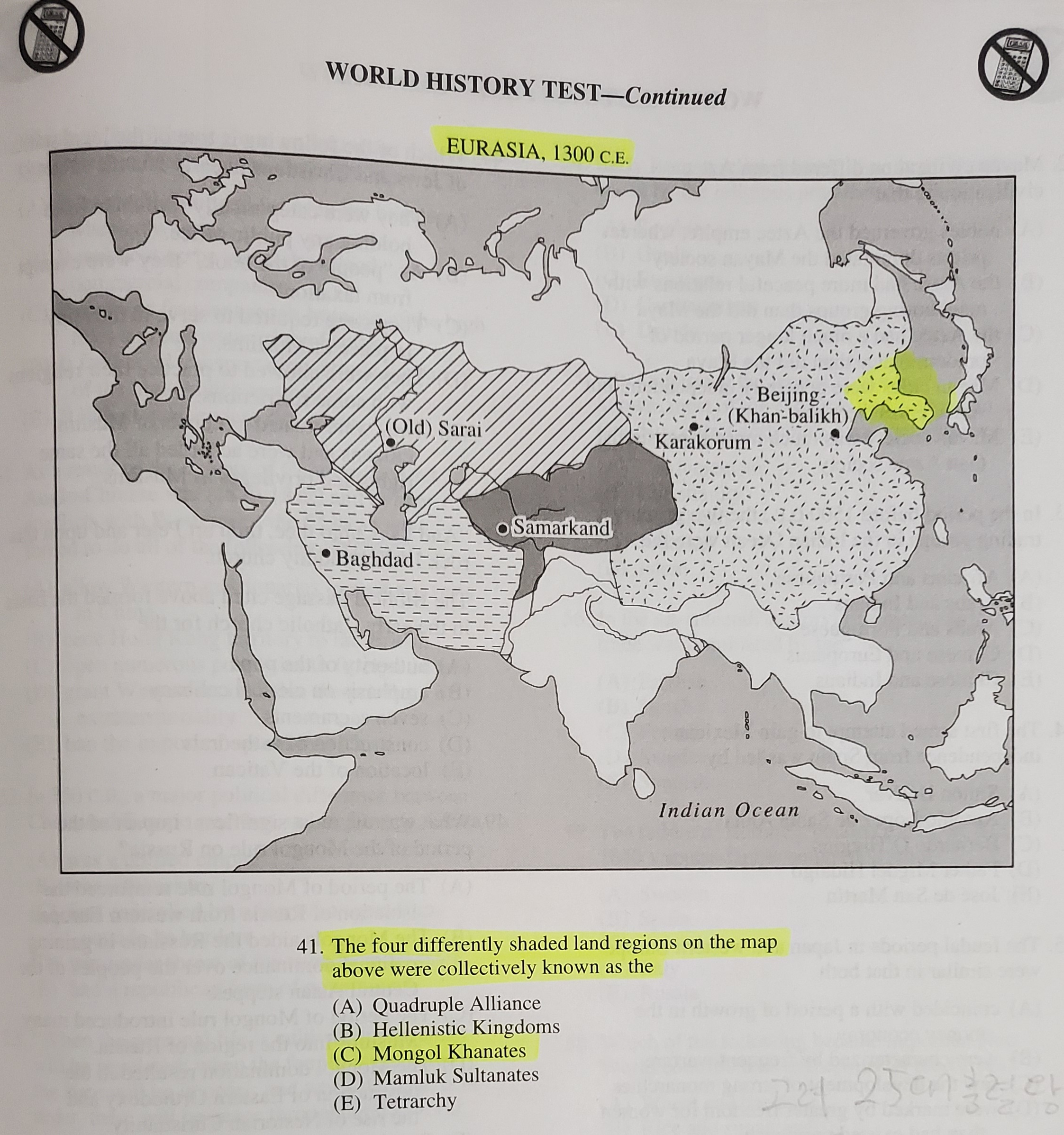
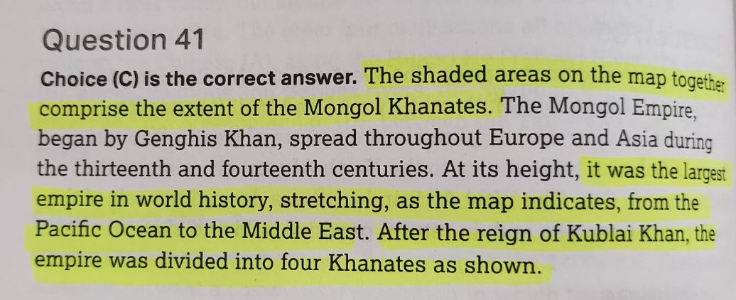
Q. The four differently shaded land regions on the map above were collectively known as the …
A. (C) Mongol Khanates
E. Choice (C) is the correct answer. The shaded areas on the map together comprise the extent of the Mongol Khanates. The Mongol Empire, began by Genghis Khan, spread throughout Europe and Asia during the thirteenth and fourteenth centuries. At its height, it was the largest empire in world history, stretching, as the map indicates, from the Pacific Ocean to the Middle East. After the reign of Kublai Khan, the empire was divided into four Khanates as shown.
오류 내용(번역)
문제. 위의 지도에서 다르게 음영 처리된 4개의 육지 지역은 집합적으로 … 라고 알려져 있다.
정답. (C) 몽골 칸국들
해설. 선택지 (C)가 정답입니다. 지도에서 음영 처리된 영역은 몽골 칸국의 범위를 구성합니다. 징기스칸에 의해 시작된 몽골 제국은 13세기와 14세기에 유럽과 아시아 전역에 퍼졌습니다. 전성기에는 지도에서 알 수 있듯이 태평양에서 중동까지 뻗어 있는 세계 역사상 가장 큰 제국이었습니다. 쿠빌라이 칸의 통치 이후 제국은 그림과 같이 4개의 칸국으로 분할되었습니다.
Original Image
Did Goryeo belong to one of Mongol Khanates? (1)
page 129
Did Goryeo belong to one of Mongol Khanates? (2)
page 152
What is wrong with the content?
무엇이 잘못되었나요?
Mongol first invaded Goryeo in 1231. Goryeo later lost part of its territory to Mongol and was subjected to internal intervention, but it was not conquered nor did lose political independence. Also, Goryeo was not one of Khanates nor belonged to any Khanate.
몽골은 1231년에 최초로 고려를 침입했습니다. 고려는 이후 몽골에 영토 일부를 빼앗기고 내정간섭을 받았으나 정치적 독립을 잃거나 정복당한 것은 아니었습니다. 또한 고려는 몽골 칸국이 아니었으며 어느 칸국에 속하지도 않았습니다.
If so, how should it be properly explained?
어떻게 수정해야 할까요?
The map should not include the territory of Goryeo as if it belonged to one of Mongol Khanates.
해당 지도는 고려의 영토가 몽골 칸국에 속해 있는 것처럼 포함시켜서는 안 됩니다.
- Full title : The Official SAT Subject Test in World History Study Guide
- Publisher : College Board; Study Guide edition (2017)
- ISBN : 9781457309335
- page number : 129, 152
According to CollegeBoard, 9,745 students took this SAT World History Test, and 69% of the students selected Choice (C) as an answer.